Do You Know How Drone Technology Is Being Used Beyond Delivery
Discover how drones are transforming industries beyond delivery, from agriculture and healthcare to disaster response and environmental monitoring.
TECH & SCIENCE
Do You Know Team
9/27/202513 min read
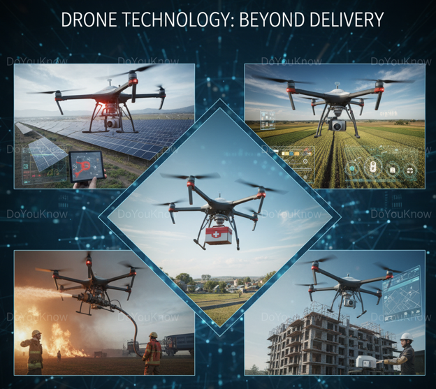
Drone technology has evolved far beyond its initial applications in military operations or recreational use. In today’s world, drones serve as versatile tools that revolutionize multiple sectors, ranging from agriculture and healthcare to environmental conservation, disaster management, infrastructure monitoring, and entertainment. While the general public often associates drones with package delivery, their true potential lies in their ability to capture high-resolution data, navigate difficult terrains, and execute complex tasks autonomously.
Modern drones are equipped with sensors, cameras, LiDAR, thermal imaging, and AI-powered systems, enabling applications that were once impossible. These aerial systems can monitor crop health, survey construction sites, deliver critical medical supplies, assess disaster damage, track wildlife, and even capture cinematic footage for films and media. The global drone market is expected to continue growing rapidly as industries discover new uses and technological advancements make drones more capable, affordable, and autonomous.
This article explores the expansive applications of drone technology beyond delivery. It highlights real-world case studies, innovative solutions, industry trends, and the future potential of drones to transform the way we live and work.
1. Agriculture: Precision Farming and Crop Monitoring
Agriculture has seen one of the most transformative impacts of drone technology. The concept of precision agriculture, which involves managing crops and soil with detailed data, has been significantly enhanced by drones. Traditionally, farmers relied on visual inspection and periodic soil testing, which often left gaps in information. Drones bridge this gap by providing accurate, real-time data across large farmlands quickly and efficiently.
Drones equipped with multispectral and thermal cameras allow farmers to monitor crop health, detect pest infestations, and identify nutrient deficiencies before they become visible. This early detection reduces the risk of crop loss and improves yield quality. In India, for instance, rice and wheat farmers in the states of Punjab and Haryana have leveraged drones to monitor large fields, detecting fungal infections early and applying targeted pesticides only where needed, which reduces chemical use and promotes sustainable farming.
Beyond crop health, drones assist with soil and field analysis. They generate high-resolution maps that help assess soil moisture, erosion-prone areas, and field variability. This enables precision irrigation and targeted fertilization, minimizing water wastage and chemical overuse. In Kenya, drones have helped maize farmers map their fields, enabling optimized fertilizer use and improved yield predictions.
Another innovative application is aerial seeding. Drones can disperse seed pods containing nutrients and fertilizers over large or hard-to-access areas, facilitating reforestation or planting in regions where manual labor is limited. Brazil and India have already piloted large-scale drone-based seeding programs, restoring degraded land efficiently.
Drones also streamline crop spraying operations. Machines like DJI’s Agras series automate pesticide and fertilizer application, reducing labor costs, increasing spraying accuracy, and limiting environmental impact. These drones use GPS-guided flight paths to cover fields uniformly, even in challenging terrains or areas with irregular topography.
The integration of AI into agricultural drones is pushing the sector further. AI algorithms analyze collected imagery to predict crop yields, forecast pest outbreaks, and recommend precise interventions, enabling farmers to make informed, data-driven decisions. Precision agriculture powered by drones is not only increasing productivity but also promoting sustainable farming practices, reducing environmental impact, and making agriculture more resilient to climate challenges.
2. Infrastructure: Surveying, Monitoring, and Maintenance
Infrastructure development and urban planning have greatly benefited from drone technology. Traditional surveying and inspection methods often involve extensive manpower, time, and potential safety hazards. Drones offer a safer, faster, and more cost-effective alternative.
Drones perform aerial surveys, capturing high-resolution images and LiDAR data to generate precise topographical maps. These maps assist engineers and planners in designing road networks, bridges, commercial complexes, and residential projects. In Dubai, drones have shortened pre-construction surveying times for large-scale projects from several weeks to mere days, demonstrating their efficiency.
During construction, drones monitor project progress in real time. High-resolution imagery and videos allow managers to compare current work with project plans, identify delays, and adjust resource allocation. This continuous monitoring reduces errors, prevents costly rework, and ensures adherence to deadlines.
Maintenance and inspection of infrastructure are other areas where drones are indispensable. Bridges, dams, pipelines, and wind turbines often require inspections in hazardous environments. Drones equipped with cameras, thermal sensors, and ultrasonic devices can perform these inspections safely and accurately. German energy companies use drones to inspect wind turbines, identifying structural issues before they cause failures and reducing downtime. Similarly, bridge inspections in the United States now rely on drones to access difficult areas, minimizing human risk while maintaining high safety standards.
Drones also assist in urban planning and smart city development. By mapping city layouts, monitoring traffic patterns, and surveying public infrastructure, drones provide governments and planners with actionable insights to optimize urban environments. The integration of drone technology into infrastructure projects improves efficiency, safety, and data accuracy, making them essential tools in modern civil engineering and urban development.
3. Disaster Management: Rapid Response and Assessment
Drones have revolutionized disaster management, providing critical support in emergency situations. Their ability to access difficult or dangerous terrains makes them invaluable during natural disasters such as earthquakes, floods, hurricanes, and wildfires.
Following a disaster, drones can perform rapid damage assessments, capturing aerial imagery and videos that help authorities prioritize response efforts. These images provide detailed overviews of affected areas, including road conditions, damaged buildings, and flooded zones. In Pakistan during the 2023 floods, drones surveyed large areas within hours, enabling faster deployment of rescue teams and efficient allocation of resources.
Search and rescue operations also benefit from drones. Thermal imaging and infrared cameras allow drones to locate survivors trapped in collapsed buildings, forests, or mountainous regions. This capability reduces the time required to find individuals and minimizes risks for rescue personnel. In Japan, drones have been routinely deployed for earthquake and typhoon responses, significantly improving rescue operations and reducing casualties.
Additionally, drones assist in emergency medical supply delivery. They transport medicines, vaccines, and blood units to areas inaccessible due to damaged roads or blocked pathways. In Rwanda, drones deliver blood supplies to remote clinics, saving lives in regions with limited infrastructure. Similarly, in Ghana, drone deliveries of vaccines have reduced transportation time from hours to minutes, ensuring timely immunization campaigns.
Beyond immediate response, drones play a crucial role in post-disaster recovery planning. Aerial surveys help authorities design resilient infrastructure, assess long-term environmental impact, and develop mitigation strategies for future disasters. By integrating drones into disaster management, governments and organizations enhance response efficiency, improve safety, and save lives.
4. Healthcare: Medical Drones and Emergency Services
The healthcare sector has witnessed groundbreaking applications of drone technology. In regions where access to medical facilities is limited or infrastructure is underdeveloped, drones provide rapid transportation of critical medical supplies.
Drones deliver vaccines, blood units, and essential medicines to hospitals, clinics, and remote villages. This reduces delivery times, ensures the cold chain is maintained for temperature-sensitive products, and enhances healthcare accessibility. Countries like Rwanda and Ghana have implemented nationwide medical drone networks that deliver life-saving supplies to rural communities, demonstrating the transformative potential of drones in healthcare logistics.
In addition to delivery, drones are being used for emergency medical response. Drones equipped with defibrillators, first aid kits, and monitoring sensors can reach patients faster than conventional ambulances. In Sweden and the United States, pilot projects have shown that drones can arrive at emergency scenes within minutes, providing immediate medical support and guidance to bystanders while professional help is en route.
Telemedicine is another area where drones are playing an emerging role. Drones with video and diagnostic sensors enable doctors to remotely monitor patients in inaccessible areas, providing medical advice and guidance in real-time. As drone technology evolves, AI integration is expected to enhance autonomous decision-making, allowing drones to prioritize deliveries and optimize routes for healthcare emergencies.
Through these applications, drones improve emergency response times, enhance healthcare accessibility in remote areas, and save lives by ensuring timely medical intervention.
5. Environmental Monitoring and Conservation
Drones have become critical tools in environmental monitoring and conservation, offering capabilities that were previously difficult or impossible to achieve. They provide real-time data, access remote areas, and reduce the need for intrusive human intervention in sensitive ecosystems.
In wildlife conservation, drones monitor animal populations, track migration patterns, and detect poaching activities. In Africa, drones are deployed to safeguard rhino and elephant populations, providing rangers with aerial views to deter illegal hunting. In the Amazon rainforest, drones monitor deforestation and illegal logging, allowing authorities to take timely action to protect biodiversity.
Drones also support pollution detection and environmental monitoring. Equipped with gas sensors, thermal cameras, and air quality monitors, drones detect pollutants in the air, water, and soil. Industries and governments use this data to enforce regulations, assess environmental risks, and monitor pollution hotspots. In China, drones are widely used to monitor air quality in urban centers, providing authorities with actionable data to improve environmental policies.
During natural disasters such as wildfires, drones provide crucial data for emergency response and damage assessment. They track fire spread, identify safe evacuation routes, and monitor affected ecosystems. Similarly, drones monitor floods, oil spills, and other environmental hazards, aiding recovery and mitigation strategies.
By enabling real-time monitoring, reducing human risk, and providing comprehensive ecological data, drones are transforming the field of environmental science and conservation.
6. Logistics and Supply Chain: Transforming Operations with Drones
Drones have significantly altered the logistics and supply chain industry by improving efficiency, reducing costs, and enabling rapid delivery in ways that were previously impossible. Beyond conventional parcel delivery, drones are being employed for inventory management, last-mile delivery, and supply chain monitoring.
6.1 Inventory Management
In large warehouses and distribution centers, inventory management is traditionally labor-intensive, requiring staff to manually scan products on shelves. Drones equipped with RFID scanners, high-resolution cameras, and AI algorithms can conduct inventory audits autonomously. They scan large volumes of goods, detect misplaced items, and update inventory databases in real-time. This reduces human error, speeds up audits, and significantly lowers operational costs.
Companies in China, such as JD.com, have deployed fleets of drones in massive warehouses to conduct 24/7 inventory monitoring. These systems can scan thousands of items in hours, a task that would take days with human labor. Additionally, AI-powered analytics on drone-collected data allow companies to identify inventory trends, optimize storage layouts, and forecast demand more accurately.
6.2 Last-Mile Delivery
The “last mile” of delivery is often the most expensive and time-consuming part of the logistics process. Drones provide a solution by delivering packages directly to consumers, bypassing traffic congestion and inaccessible locations. Drones are particularly useful in remote or rural areas where conventional delivery trucks cannot reach efficiently.
Medical drones have demonstrated life-saving potential in last-mile delivery. In Rwanda and Ghana, drones deliver vaccines, blood units, and essential medicines to rural clinics, reducing delivery times from hours to minutes. Similarly, drones are used in disaster-hit areas to deliver critical supplies to affected populations, highlighting the dual utility in both logistics and humanitarian response.
6.3 Supply Chain Monitoring
Beyond delivery, drones monitor supply chains in real-time, tracking goods during transportation, monitoring conditions like temperature or humidity for sensitive products, and providing companies with comprehensive visibility. For industries handling perishable goods, pharmaceuticals, or fragile items, drones ensure that shipments remain intact and compliant with quality standards.
For example, pharmaceutical companies use drones to transport vaccines under strict cold-chain conditions, with sensors constantly monitoring temperature, location, and delivery times. This real-time oversight reduces spoilage, ensures compliance, and enhances customer confidence.
The adoption of drones in logistics is projected to grow exponentially, driven by advancements in AI routing, battery efficiency, and autonomous flight, making them a cornerstone of modern supply chain innovation.
7. Entertainment, Media, and Filmmaking: Aerial Creativity Unleashed
Drone technology has opened new horizons in the entertainment and media industry, offering perspectives that were previously difficult or impossible to achieve.
7.1 Aerial Photography
From real estate to tourism, drones capture stunning aerial photographs and videos, providing unique perspectives of landscapes, landmarks, and events. High-resolution cameras and stabilized gimbals allow drones to produce cinematic-quality imagery that enhances visual storytelling. In tourism marketing, aerial drone footage of national parks, beaches, and cities has become an essential tool to attract visitors by showcasing destinations in dramatic, sweeping views.
7.2 Filmmaking and Television Production
Drones have become indispensable in film and television production. They can execute complex shots, including moving tracking sequences, panoramic sweeps, and high-altitude aerial perspectives. Traditional methods like cranes, helicopters, or cable systems are often costly and limited in mobility, whereas drones offer flexibility and reduced production costs.
Hollywood and Bollywood productions now routinely employ drones to capture action sequences, chase scenes, and aerial landscapes. For example, the production of major international films has used drone technology to film intricate mountain chases, urban rooftops, and large-scale crowd scenes, delivering dynamic visuals impossible with conventional equipment.
7.3 Live Event Broadcasting and Journalism
Drones are transforming live broadcasting and journalism. Media outlets use drones to cover concerts, sports events, political rallies, and disaster situations. In situations where traditional camera crews cannot safely operate, drones provide real-time aerial coverage.
During natural disasters, journalists deploy drones to capture aerial images of floods, hurricanes, or wildfires, providing critical information to the public and authorities. The agility and speed of drones allow media teams to report timely updates with minimal risk, changing the landscape of news reporting and event coverage.
8. Education and Research: Scientific Exploration from Above
Drones have significant potential in education and research, enhancing data collection, analysis, and learning opportunities.
8.1 Geospatial Studies and Mapping
Drones equipped with LiDAR, multispectral, and high-resolution cameras facilitate geospatial studies, urban planning, and geological research. Universities and research institutes deploy drones to create 3D maps, study landforms, and analyze urban environments. The ability to capture high-resolution data from difficult or dangerous locations makes drones an indispensable tool in geospatial sciences.
8.2 Biological and Ecological Research
Ecologists and biologists use drones to study ecosystems, monitor wildlife, and track environmental changes. Drones allow for minimal disruption to wildlife while providing accurate data on animal behavior, population dynamics, and habitat conditions. In the Amazon rainforest, drones track deforestation, monitor biodiversity, and detect illegal logging activities, aiding conservation efforts.
Marine biologists use drones to monitor coastal ecosystems, track marine mammals, and study coral reef health. The use of drones reduces the need for boats or manned aircraft, minimizing costs and environmental impact.
8.3 Disaster Science and Climate Research
Drones support climate scientists in monitoring natural disasters, including floods, wildfires, hurricanes, and glacial movements. By capturing aerial imagery and sensor data, drones allow researchers to study disaster impacts, model climate change effects, and develop predictive analytics for future mitigation strategies. This real-time, high-resolution data is invaluable for both academic research and policy development.
8.4 Educational Applications
Drones are increasingly incorporated into educational programs, from high school STEM curricula to university-level engineering and robotics courses. Students gain hands-on experience in flight operations, sensor integration, and AI programming, preparing them for careers in emerging technology sectors. Drone-based learning fosters innovation, problem-solving skills, and familiarity with cutting-edge technology.
9. Emerging Trends and Future Potential
The future of drone technology is poised for exponential growth, driven by advancements in artificial intelligence, autonomous navigation, IoT integration, and global regulatory frameworks.
9.1 AI-Powered Autonomous Drones
Artificial intelligence enables drones to navigate complex environments autonomously, avoid obstacles, and perform tasks with minimal human intervention. AI-powered drones can analyze collected data in real time, prioritize actions, and adapt to changing conditions, enhancing efficiency across industries.
9.2 Drone Swarm Technology
Swarm technology allows multiple drones to operate in coordinated formations. Swarm systems are used for large-scale agricultural monitoring, disaster response, surveillance, and environmental mapping. Coordinated drones can cover vast areas quickly, collect synchronized data, and execute complex tasks simultaneously, opening new possibilities in logistics, defense, and scientific research.
9.3 Integration with Internet of Things (IoT)
Connected drones integrated with IoT networks enable real-time data sharing, monitoring, and analytics. Smart cities use IoT-enabled drones to monitor traffic, infrastructure, and environmental conditions. In agriculture, drones connected to IoT sensors provide comprehensive insights into soil moisture, crop health, and weather conditions, optimizing farm management and resource utilization.
9.4 Regulatory Developments and Global Adoption
Governments worldwide are establishing drone corridors, licensing frameworks, and safety standards to facilitate commercial drone operations while ensuring public safety. Regulatory clarity is enabling industries to adopt drones more confidently, accelerating innovation in healthcare, logistics, agriculture, and emergency services.
9.5 Futuristic Applications
Emerging applications include drone taxis, autonomous cargo transport, wildfire suppression, urban air mobility, and environmental restoration projects. As battery technology, AI algorithms, and flight autonomy improve, drones will perform increasingly complex missions, revolutionizing multiple sectors simultaneously.
10. Expanded Global Case Studies
10.1 India: Drones in Agriculture and Disaster Management
In India, drones are widely used in agriculture for crop monitoring, pest detection, and irrigation management. Government programs in states like Telangana and Maharashtra deploy drones to assess farm health, map soil variability, and improve productivity. During monsoon floods, drones assist disaster response teams in mapping affected areas, delivering essential supplies, and assessing infrastructure damage.
10.2 United States: Infrastructure and Healthcare
In the U.S., drones inspect bridges, highways, and power lines, reducing risks to human inspectors. Companies like Zipline use medical drones to deliver blood and vaccines to remote areas, improving healthcare access and emergency response times.
10.3 Africa: Wildlife Conservation
In Africa, drones protect endangered species, monitor poaching activity, and map habitats. Thermal imaging drones provide anti-poaching units with real-time surveillance, significantly reducing illegal hunting incidents.
10.4 Europe: Environmental Monitoring and Research
European countries deploy drones for environmental monitoring, including air quality assessment, pollution detection, and climate research. In Germany, drones are used to monitor forests, detect environmental hazards, and provide data for policy planning and conservation efforts.
10.5 Asia-Pacific: Smart Cities and Logistics
Countries like China, Japan, and Singapore integrate drones into urban infrastructure and logistics systems. Drones monitor traffic, inspect public facilities, and assist in warehouse inventory management, forming part of the broader smart city ecosystem.
Frequently Asked Questions (FAQs)
Q1: How are drones improving precision agriculture?
Drones provide real-time monitoring of crop health, soil conditions, and irrigation needs. High-resolution imagery and AI analysis allow farmers to detect issues early, optimize fertilizer use, and increase yields.
Q2: Can drones deliver medical supplies in emergencies?
Yes, drones transport vaccines, blood units, medicines, and emergency kits, especially to remote or disaster-affected areas, reducing delivery times and saving lives.
Q3: How do drones assist in disaster management?
Drones perform rapid damage assessment, locate survivors using thermal imaging, deliver essential supplies, and provide real-time data for emergency planning.
Q4: Are drones used in environmental conservation?
Absolutely. Drones monitor wildlife, detect poaching, track deforestation, and measure pollution levels, aiding conservation and ecological research.
Q5: Can drones replace human inspections in infrastructure?
Drones significantly reduce the need for manual inspections in hazardous environments while providing accurate and high-resolution data for maintenance planning.
Q6: What industries benefit most from drones?
Agriculture, healthcare, disaster management, logistics, environmental monitoring, infrastructure, media, and scientific research are primary beneficiaries.
Q7: How are drones evolving with AI and IoT?
AI enables autonomous navigation and real-time decision-making, while IoT integration allows drones to transmit data instantly, enhancing analytics and operational efficiency.
Q8: Are drones cost-effective for small businesses?
Yes. Rental and service-based drone models allow small businesses to leverage drone technology without heavy capital investment, improving efficiency and competitiveness.
Q9: What are drone swarms, and how are they used?
Drone swarms are coordinated groups of drones operating together for large-scale monitoring, disaster response, agricultural surveying, or surveillance, providing speed and efficiency.
Q10: Will drones replace traditional delivery vehicles?
While drones complement traditional logistics, they are most effective in last-mile delivery, remote areas, and time-sensitive transportation. Full replacement is unlikely in the near future.
Conclusion
Drone technology has expanded far beyond delivery applications, transforming agriculture, healthcare, disaster management, infrastructure, environmental monitoring, logistics, entertainment, and research. With advancements in AI, autonomous navigation, IoT integration, and regulatory support, drones are positioned to revolutionize multiple industries further.
From improving crop yields and delivering life-saving medical supplies to monitoring ecosystems and filming cinematic sequences, drones have become indispensable tools in modern society. As the technology continues to evolve, industries that adopt drones will benefit from enhanced efficiency, reduced costs, improved safety, and sustainable practices.
The future promises even greater integration of drones into daily operations, with autonomous fleets, drone taxis, swarm technologies, and smart city applications paving the way for a world where drone technology is central to innovation, problem-solving, and operational excellence.
Drones are no longer just machines that fly—they are transformative instruments shaping the future.
#DroneTechnology #Innovation #PrecisionAgriculture #MedicalDrones #DisasterManagement #EnvironmentalMonitoring #AI #DroneMapping #LogisticsDrones #FutureTech #DoYouKnow
Knowledge
Empowering minds with reliable educational content daily.
Newsletter Signup
© 2025 DoYouKnow. All rights reserved.
Stay Ahead of the Trends – Join Our Newsletter